Geopolitics Intelligence #007
The Indo-Pacific — Maritime Power, Technology Supply Chains and Pakistan’s Strategic Linkages
A FutureWorld Intelligence report applying the 9-pillar geopolitics framework to the Indo-Pacific’s sea lanes, semiconductor geography, Pakistan’s Arabian Sea linkages, alliances, law and future scenarios.
Start the ReportBack to Geopolitics PageIndo-PacificPakistanGwadarMalaccaSemiconductorsG-D-T-L-S
Malacca oil flow
22.5 million b/d in 2024; 23.2 million b/d in 1H25.
Maritime trade
Around 80% of goods trade volume moves by sea.
Chip geography
The Indo-Pacific is critical for semiconductor supply chains.
Pakistan keyword
Gwadar, Arabian Sea, CPEC and western Indo-Pacific connectivity.
- Publication family
- Research and Strategic Analysis
- Publication type
- FWI Strategic Intelligence Report
- Domain
- Geopolitics Intelligence
- Series and number
- Geopolitics Intelligence #007
- Institutional author
- FutureWorld Intelligence
- Publication year
- 2026
- Current web edition
- 1.0
- Metadata updated
- 15 July 2026
- Purpose
- Assess a strategic geopolitical system, region, capability or risk
- Intended audience
- Policy readers, researchers, analysts and informed public
- Method and evidence basis
- Desk-based G-D-T-L-S strategic analysis
- Evidence cut-off
- The exact historical evidence cut-off was not recorded when the original web publication was prepared. Source currency will be confirmed during retrospective validation.
- Limitations and disclosures
- Classification and metadata do not independently validate substantive claims. Citation, factual, originality, AI-use, rights and conflict-of-interest checks remain part of the pending retrospective validation.
Validation note: This classification does not itself validate the publication. Retrospective factual, citation, originality, disclosure and readiness checks must be completed and human-approved before the status can change to “Validated — human approved.”
Report navigation
Headings and visual structure
Executive summary
The Indo-Pacific is the world’s maritime-industrial operating system
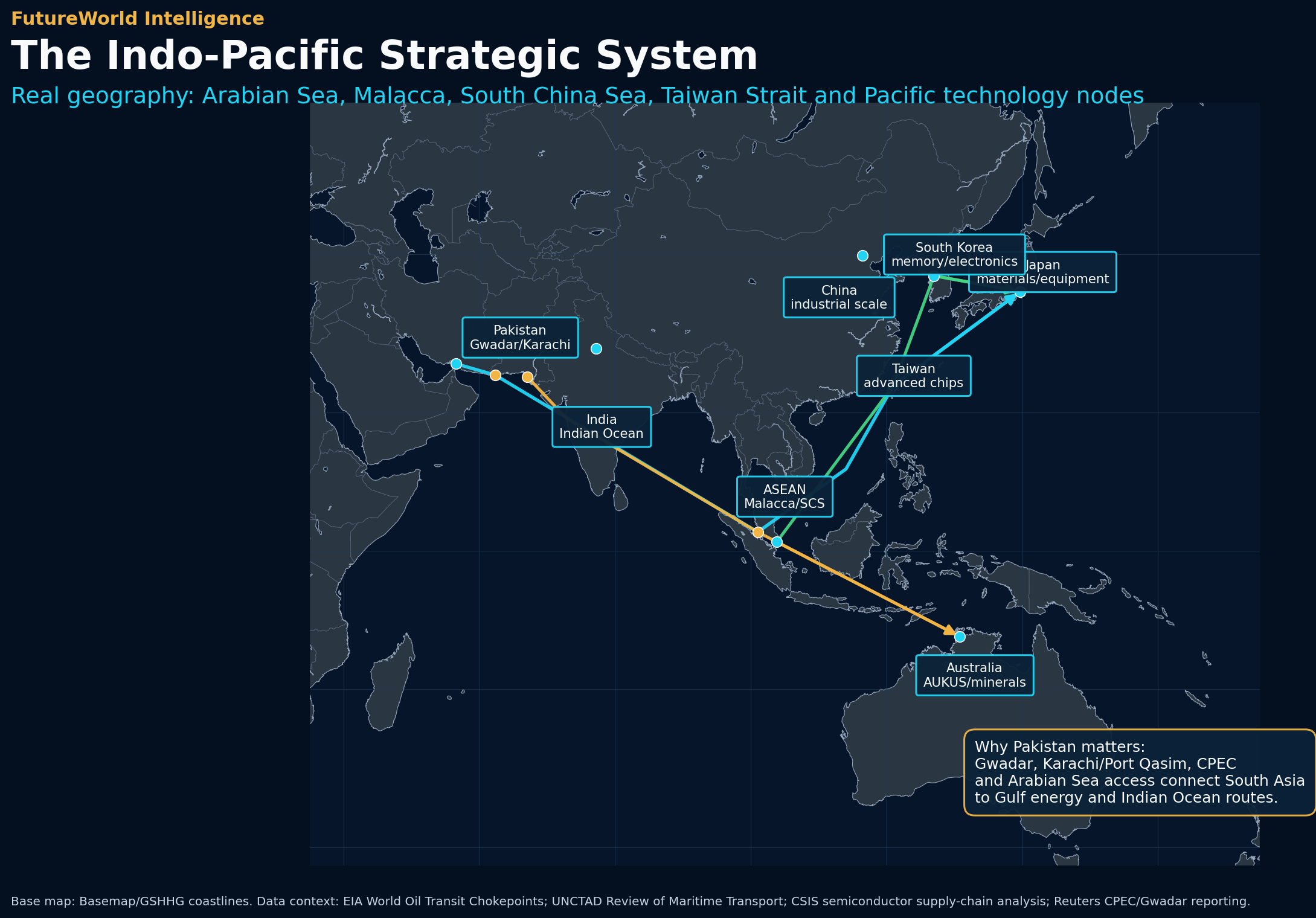
The Indo-Pacific should be understood as a maritime, industrial, technological and security system. It links the Gulf energy artery, Pakistan’s Arabian Sea location, Indian Ocean routes, ASEAN chokepoints, East Asian manufacturing and the Pacific alliance network.
The Indo-Pacific is not simply a diplomatic slogan. It is a strategic space where oceans, ports, islands, straits, semiconductor facilities, energy routes, industrial corridors, naval bases and regional institutions interact. It stretches from the eastern coast of Africa and the Arabian Sea through the Indian Ocean, the Bay of Bengal, Southeast Asia, the South China Sea, the Taiwan Strait, East Asia and the wider Pacific. In this wide system, maritime geography is the first layer of power. Whoever depends on seaborne trade, energy imports, container routes, cables or naval access is affected by the stability of this space.
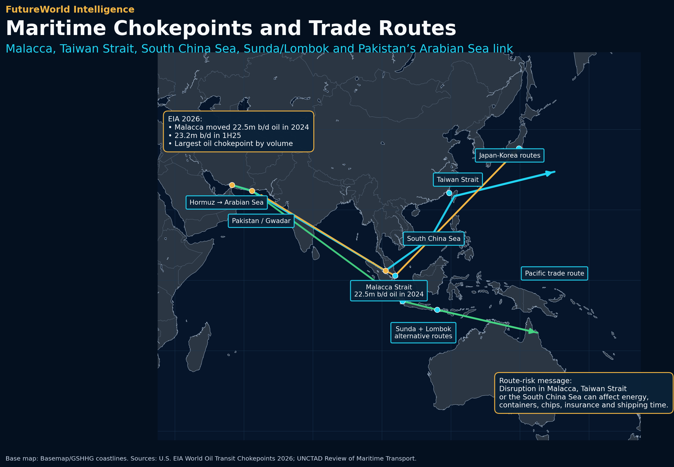
The Gulf report explained the world’s energy arteries. This report explains the world’s technology and trade arteries. The two are connected. Energy from the Gulf moves eastward through the Arabian Sea and the Strait of Malacca toward China, Japan, South Korea, Taiwan and Southeast Asia. Manufactured goods and electronic components move through the same maritime system in the opposite direction toward Europe, the Middle East and Africa. UNCTAD states that around 80 percent of the volume of international goods trade is carried by sea, making maritime transport the physical backbone of globalization. EIA’s 2026 chokepoint update estimates that the Strait of Malacca moved 22.5 million barrels per day of crude oil and petroleum liquids in 2024 and 23.2 million barrels per day in the first half of 2025, making it the largest oil transit chokepoint by volume in that dataset.
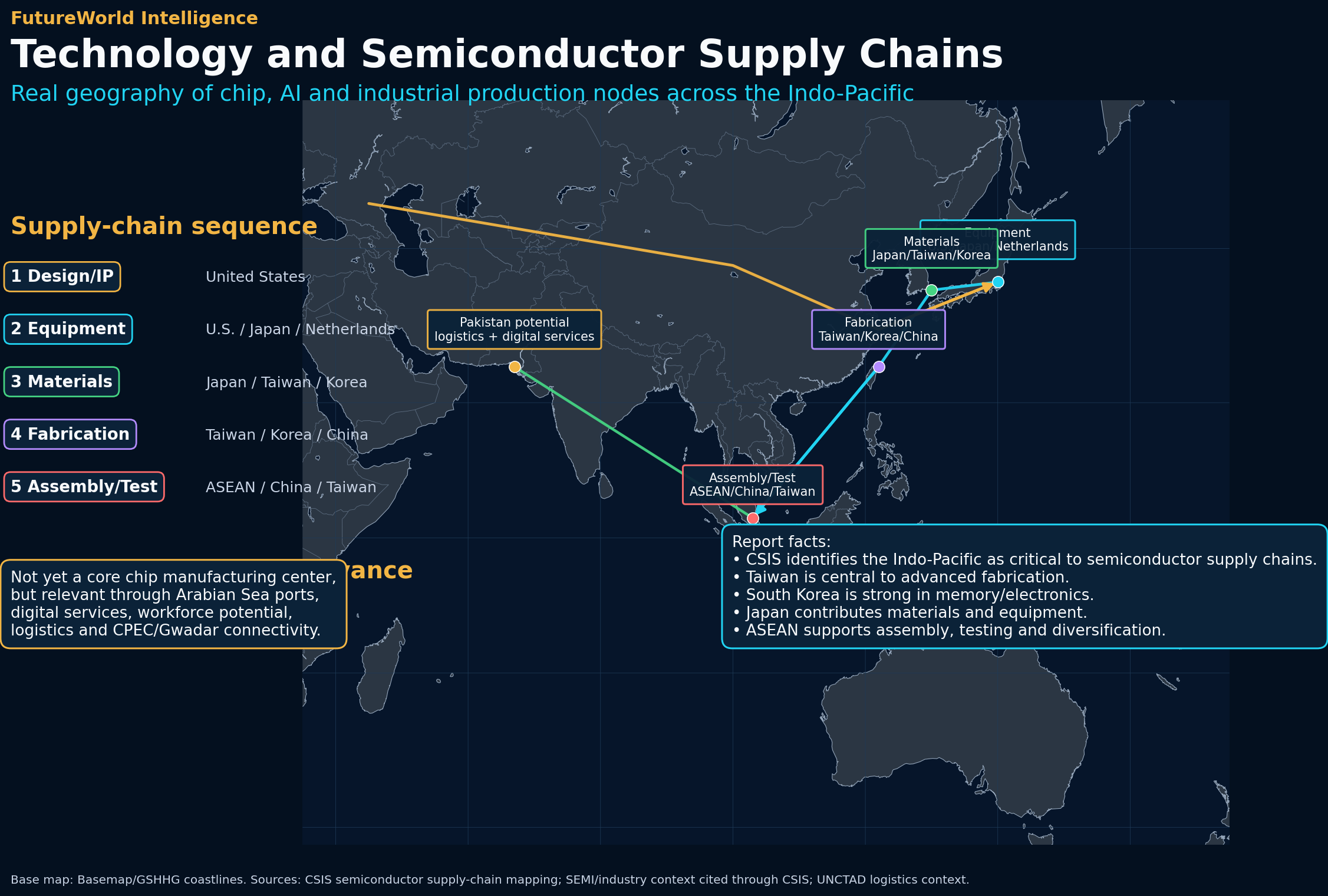
Technology is the second layer. Semiconductors make the Indo-Pacific more than a shipping region. CSIS describes the semiconductor supply chain as increasingly central to international relations and notes that the Indo-Pacific is its critical region. Taiwan, South Korea, Japan, China, Singapore, Malaysia, Vietnam, the Philippines and the United States each play distinct roles in design, equipment, fabrication, materials, assembly, testing and final electronics. This is why a crisis in the Taiwan Strait, South China Sea or Malacca Strait can affect not only security but also cars, phones, data centers, AI systems, satellites, power grids and military platforms.
Pakistan should be included clearly in this topic. Pakistan is not an East Asian semiconductor center, but it is geographically important to the western Indo-Pacific. Gwadar, Karachi and Port Qasim face the Arabian Sea, connecting Pakistan to the Gulf, the Indian Ocean, East Africa and the wider maritime system. CPEC and Gwadar create a China-Pakistan connectivity narrative that links western China, the Karakoram Highway, Khunjerab, Balochistan and the Arabian Sea. This does not mean every promise has been realized. Security, governance, local development and infrastructure constraints remain serious. But in search and strategic terms, Pakistan belongs in this report because it is a western hinge between the Gulf energy system, China’s continental access ambitions, Central Asian connectivity, South Asia, and the Indian Ocean.
The report’s central argument is that the Indo-Pacific is a system of systems: maritime lanes, technology supply chains, alliances, ports, legal rules, resource flows and national capabilities. Its future can move in several directions. It may remain a stable maritime-trade system; it may fragment into rival technology blocs; it may experience a maritime crisis in the Taiwan Strait, South China Sea or Malacca route; or it may become a more resilient multipolar region where ASEAN, India, Pakistan, Japan, Australia and others diversify partnerships and routes. FutureWorld should analyze this region with disciplined neutrality: map geography, collect data, apply theory, identify law and build scenarios.
Why the Indo-Pacific matters
Geographic system: Indian Ocean to Pacific Ocean
The Indo-Pacific links two oceanic worlds. The Indian Ocean carries energy, commodities and trade between the Gulf, East Africa, South Asia and Southeast Asia. The Pacific Ocean connects East Asian manufacturing, North American markets, island chains, naval alliances and digital supply chains. Between them sit the maritime corridors of Southeast Asia: Malacca, Singapore, Sunda and Lombok. These passages connect energy producers in the Gulf and Africa with Asian consumers and industrial systems. They also connect factories in East and Southeast Asia with global consumers.
The region’s geography is layered. The first layer is the western gateway: the Gulf, Arabian Sea, Pakistan, Oman, Iran and India’s western coast. The second layer is South Asia: India, Pakistan, Sri Lanka and Bangladesh, which connect the Arabian Sea, Bay of Bengal and land corridors toward Central Asia and western China. The third layer is Southeast Asia: Indonesia, Malaysia, Singapore, Thailand, Vietnam and the Philippines, where the most important sea lanes converge. The fourth layer is East Asia: China, Taiwan, Japan and South Korea, where semiconductor, electronics, shipbuilding and industrial capacity are concentrated. The fifth layer is the Pacific alliance and island system, linking Australia, the United States, Japan, Korea, Guam and the Pacific islands.
Pakistan matters because it sits at the western edge of this system. Its Arabian Sea coast gives it maritime relevance beyond South Asia. Gwadar is located near the routes connecting the Gulf to the Indian Ocean. Karachi and Port Qasim remain Pakistan’s core commercial maritime hubs. CPEC gives Pakistan a China-linked connectivity narrative that ties the Arabian Sea to western China and Central Asia. This makes Pakistan a keyword-rich and strategically relevant component of any Indo-Pacific report. It also requires careful analysis: potential does not equal performance. A port becomes strategic only when security, infrastructure, customs, hinterland connectivity, energy supply, local legitimacy and commercial throughput are present together.
For FutureWorld, the Indo-Pacific should therefore not be treated only as a China-U.S. competition zone. It is a region where Pakistan, India, ASEAN, the Gulf, Japan, South Korea, Taiwan, Australia and Pacific actors all matter in different ways. A good map must show routes and systems, not only flags.
Maritime chokepoints and sea lanes
Malacca, Taiwan Strait, South China Sea and alternative routes
The Strait of Malacca is the central maritime artery of the Indo-Pacific. EIA’s 2026 chokepoint report identifies it as the largest oil transit chokepoint by volume in the world, with 22.5 million barrels per day in 2024 and 23.2 million barrels per day in the first half of 2025. It links the Indian Ocean and Pacific Ocean and provides the shortest sea route between Middle East energy suppliers and East Asian markets. For China, Japan, South Korea, Taiwan and Southeast Asia, Malacca is not merely a waterway; it is a strategic dependency.
Malacca is not the only sensitive point. The South China Sea is a major maritime space through which energy, containers and naval forces move. The Taiwan Strait is one of the most politically sensitive maritime zones because it connects questions of sovereignty, semiconductor production, naval access and great-power deterrence. The Sunda and Lombok Straits provide alternatives to Malacca but add distance and cost. If Malacca is disrupted, traffic can shift south through Indonesian waters, but this increases voyage time and creates new congestion and security pressures.
The western side also matters. The Gulf-to-Asia energy route begins near Hormuz and moves across the Arabian Sea. Pakistan’s coast sits along this wider western edge of the Indo-Pacific. Gwadar, Karachi and Port Qasim can be analyzed as part of the same maritime geography, even if their present capacity differs from larger hubs such as Singapore or Shanghai. Pakistan’s importance is not that it controls Malacca or the Taiwan Strait; it is that it connects the Gulf, South Asia, China-linked land corridors and the Arabian Sea.
Maritime chokepoints convert geography into risk. A disruption can raise insurance costs, delay cargo, increase energy prices, reroute shipping, affect industrial production and strengthen naval competition. This is why maritime resilience matters: diversified routes, better ports, digital tracking, anti-piracy cooperation, port security, legal clarity and crisis communication can reduce systemic risk.
Technology and semiconductor supply chains
The Indo-Pacific as a chip and AI production system
The Indo-Pacific is now as important for technology as the Gulf is for energy. Semiconductors are the foundations of AI, phones, vehicles, drones, satellites, cloud infrastructure, military systems, renewable-energy controls and modern factories. CSIS argues that the semiconductor supply chain increasingly rivals oil and gas in its importance to international relations and that the Indo-Pacific is the critical region. This makes technology geography a central part of geopolitics.
The semiconductor value chain is highly specialized. The United States is strong in design, core intellectual property, equipment and ecosystem coordination. Japan is strong in materials, components and equipment. Taiwan is central to advanced foundry manufacturing. South Korea is strong in memory chips and electronics. China has scale in manufacturing, market demand and policy ambition. ASEAN countries such as Singapore, Malaysia, Vietnam and the Philippines matter for assembly, testing, packaging, electronics and supply-chain diversification. The Netherlands matters through advanced lithography, even though it is outside the Indo-Pacific. The point is that no single state can easily perform all steps alone.
CSIS notes that the Indo-Pacific, including the United States in its analytical frame, holds the vast majority of the world’s semiconductor wafer fabrication facilities: 1,215 out of 1,470 confirmed facilities were located within the Indo-Pacific. It also notes that ATP facilities are heavily concentrated in Indo-Pacific countries, including Taiwan, China and Southeast Asia. These figures show why the Indo-Pacific is not only a region of ships and naval bases. It is a region where supply-chain specialization, manufacturing concentration and geopolitical exposure converge.
Pakistan’s semiconductor role should be described with honesty. Pakistan is not currently a major semiconductor fabrication node. It does not compete with Taiwan, South Korea or Japan in advanced chips. But Pakistan can become relevant in adjacent roles: software services, AI education, data services, electronics assembly, logistics, vocational training, port connectivity, and long-term industrial policy. The first step is not to claim high-end chip capability; it is to build human capital, power reliability, investment confidence, secure industrial zones, and partnerships that can attract lower-risk assembly, testing, repair, component manufacturing and digital services. This honest framing makes the report more credible and also strengthens search relevance for Pakistan, Gwadar, CPEC, technology supply chains and Indo-Pacific strategy.
Trade, ports and industrial corridors
From shipping routes to production networks
Trade corridors in the Indo-Pacific combine ports, industrial zones, energy routes, container shipping, undersea cables, customs systems and land connections. Singapore is a global maritime and logistics hub. Shanghai, Shenzhen, Busan, Yokohama, Kaohsiung and other East Asian ports support manufacturing exports. ASEAN ports connect assembly networks and regional production. India’s ports connect the Arabian Sea and Bay of Bengal to global markets. Pakistan’s Karachi, Port Qasim and Gwadar are part of the western maritime edge, with different levels of present capability and future potential.
The Indo-Pacific also contains industrial corridors. China’s coastal manufacturing belt, Japan’s industrial clusters, South Korea’s electronics system, Taiwan’s semiconductor ecosystem, ASEAN’s assembly and logistics networks, India’s manufacturing and services growth, and Pakistan’s CPEC-linked corridor all represent attempts to connect geography with industry. The strongest corridors are not only roads or ports. They combine power supply, skills, finance, customs efficiency, ports, rail, roads, legal predictability and security.
Pakistan’s corridor logic is especially important. CPEC and Gwadar can be studied as a western Indo-Pacific connectivity project, but this should be done with a balanced approach. The potential is clear: Arabian Sea access, proximity to the Gulf, China-linked overland narratives, and possible links to Central Asia and Afghanistan. The constraints are also clear: security concerns, local development grievances, financing, power supply, port utilization, administrative capacity and regional tensions. For FutureWorld, this balanced framing is essential. It supports Pakistan keywords but avoids exaggeration.
Pakistan in the Indo-Pacific
Gwadar, CPEC and the western maritime hinge
Pakistan should be included as a serious but carefully framed Indo-Pacific actor. Geographically, Pakistan faces the Arabian Sea and sits near the Gulf energy system. Its major ports include Karachi and Port Qasim, while Gwadar provides a strategic narrative of deeper western maritime access. Pakistan also links the Indian Ocean with Central Asian and western Chinese connectivity concepts through roads, passes and political geography. This makes Pakistan relevant for Indo-Pacific search terms and for FutureWorld’s regional intelligence structure.
Reuters reported in 2026 that China and Pakistan aimed to revamp CPEC and Gwadar, with emphasis on high-quality development, third-party participation, infrastructure upgrades, Khunjerab Pass and Karakoram Highway improvements, while security remained a major concern. This is exactly the dual reality FutureWorld should explain: Gwadar is strategically important, but strategic importance does not automatically translate into economic transformation. Ports need hinterland connections, local legitimacy, investor confidence, container flows, energy reliability and security.
Pakistan’s greatest opportunity is not to claim dominance in the Indo-Pacific. Its opportunity is to position itself as a western connector: Gulf to South Asia, Arabian Sea to Central Asia, China to the Indian Ocean, and a future logistics-digital-industrial bridge if domestic capacity improves. Its greatest risk is underperformance: if security, governance, local inclusion and infrastructure lag behind the narrative, strategic geography remains unrealized potential. The FutureWorld method should therefore treat Pakistan as a hinge, not as a fantasy. A hinge can become powerful if connected well; it can become irrelevant if the door does not move.
Security, alliances and strategic competition
U.S. alliances, Quad, AUKUS, ASEAN, China, India and Pakistan
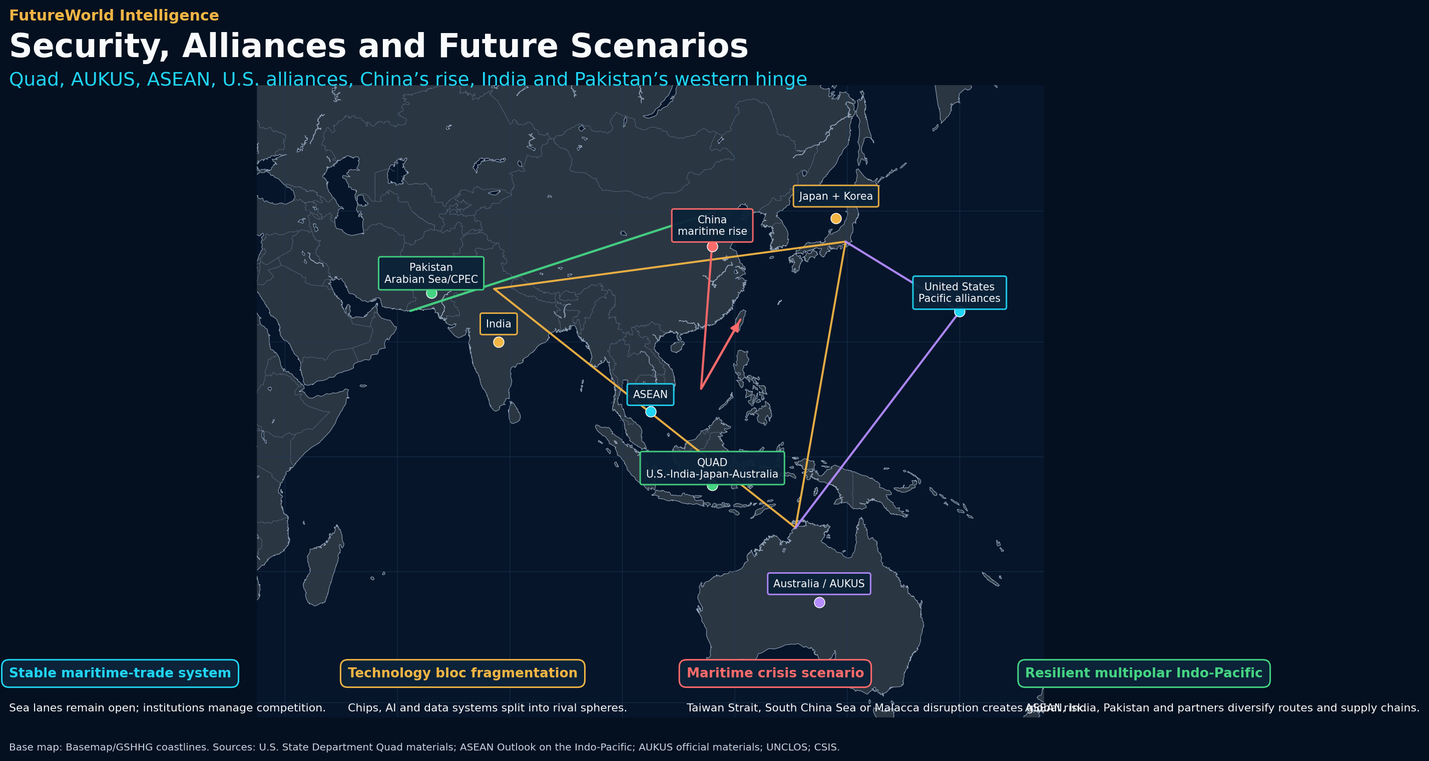
The Indo-Pacific security architecture is dense. The United States has alliances and partnerships with Japan, South Korea, Australia, the Philippines and others. The Quad connects the United States, India, Japan and Australia around maritime security, resilient supply chains, technology, infrastructure and regional coordination. AUKUS links Australia, the United Kingdom and the United States around defense technology, submarines and advanced capabilities. ASEAN remains central because Southeast Asian states sit around key sea lanes and prefer regional balance rather than forced bloc politics. China’s maritime rise, naval modernization, coast guard activities and industrial scale make it a central actor in any Indo-Pacific analysis.
Pakistan’s security role is different from that of U.S. treaty allies. Pakistan is not part of Quad or AUKUS, and it should not be described as such. Its relevance comes from geography, China partnership, CPEC, Arabian Sea access, nuclear status, Afghanistan and Central Asia linkages, and its position near the Gulf. Pakistan’s alignment with China means that its maritime and corridor role is watched by regional actors. At the same time, Pakistan needs stable relations with the Gulf, trade access, financial support, and balanced diplomacy to avoid becoming trapped in bloc pressure.
Strategic competition in the Indo-Pacific is not only military. It includes technology controls, chip supply chains, port access, undersea cables, energy flows, investment rules, standards, cyber security, AI governance and infrastructure finance. A naval incident may create headlines, but a semiconductor export control or port-financing decision may reshape power more quietly. FutureWorld should therefore map both hard security and geo-economics together.
International law and maritime rules
UNCLOS, navigation, sovereignty and crisis management
Law is central to the Indo-Pacific because many strategic questions are maritime. UNCLOS provides the legal framework for territorial seas, exclusive economic zones, high seas freedoms and navigational rights. The South China Sea, Taiwan Strait, Malacca Strait, archipelagic sea lanes, maritime boundaries and port access all require legal analysis. The UN Charter matters where disputes involve threats or use of force. International humanitarian law becomes relevant if armed conflict affects civilians, ports, ships, infrastructure or islands.
The legal layer should not be confused with political claims. A state may make a claim; another may reject it; a court or tribunal may interpret a legal position; and naval forces may create facts at sea. FutureWorld’s role is to separate these layers. In the Indo-Pacific, legal questions affect fishing, energy exploration, military passage, surveillance, artificial islands, sanctions, cargo insurance and crisis behavior. For Pakistan, legal analysis also touches maritime zones, port governance, regional trade rules, and the legal terms of corridor and investment agreements.
Theory lens
Sea power, realism, liberal institutionalism and geo-economics
Sea power theory helps explain why the Indo-Pacific is central. Maritime routes, ports, naval access, islands and chokepoints shape state power. Realism explains deterrence, alliance building, naval modernization and uncertainty around Taiwan and the South China Sea. Liberal institutionalism explains why ASEAN, Quad working groups, trade frameworks, standards and legal mechanisms matter. Geo-economics explains how semiconductors, ports, sanctions, technology controls, investment screening and supply-chain diversification become instruments of power.
Constructivism is also useful because identity, historical memory, narratives and legitimacy affect regional behavior. Climate-security theory matters because island states, coastal infrastructure, fisheries, typhoons, sea-level rise and disaster risk shape the future of the Pacific and Indian Ocean. Dependency and world-systems lenses can help analyze how weaker states negotiate with larger powers over infrastructure and finance. Pakistan’s own position can be analyzed through geo-economics and regional power theory: geography gives potential, but state capacity determines whether that potential becomes influence.
FutureWorld method
G-D-T-L-S applied to the Indo-Pacific
| Step | Question | Indo-Pacific and Pakistan application |
|---|
| G — Geography | Where are the sea lanes, chokepoints, ports, islands, straits and corridors? | Map Malacca, South China Sea, Taiwan Strait, Sunda/Lombok, Gwadar, Karachi, Port Qasim, Bay of Bengal, Japan-Korea routes and Pacific island chains. |
| D — Data | What evidence defines the system? | Use EIA chokepoint flows, UNCTAD maritime trade statistics, CSIS semiconductor supply-chain data, World Bank/IMF indicators and official institutional sources. |
| T — Theory | Which lenses explain behavior? | Use sea power, realism, liberal institutionalism, geo-economics, constructivism and climate-security analysis. |
| L — Law | Which legal rules apply? | Use UNCLOS, UN Charter, trade agreements, corridor contracts, maritime navigation rules and crisis-management mechanisms. |
| S — Scenario | What pathways are plausible? | Stable trade, technology fragmentation, maritime crisis, or resilient multipolar Indo-Pacific. |
FutureWorld practice: every Indo-Pacific update should include one route map, one technology supply-chain chart, one Pakistan/Gwadar link, one security-alliance layer and one scenario matrix.
Scenario pathways
Four futures for the Indo-Pacific system
1. Stable maritime-trade system
Sea lanes remain open, trade continues, and institutions manage competition. Malacca, the South China Sea and Taiwan Strait remain tense but functional. ASEAN, Japan, India, Australia, Pakistan and others benefit from connectivity, though strategic competition remains in the background.
2. Technology bloc fragmentation
Semiconductor, AI, cloud, data and equipment systems split into rival blocs. Export controls, investment restrictions, standards competition and supply-chain duplication increase costs. Pakistan and developing states face pressure to choose platforms, financing sources and technology standards.
3. Maritime crisis scenario
A Taiwan Strait, South China Sea or Malacca-linked crisis disrupts shipping, energy, insurance and manufacturing. Global industry feels the shock because containers, oil, LNG and chips move through the same strategic space. Alternative routes through Sunda, Lombok or around Australia become more important.
4. Resilient multipolar Indo-Pacific
States diversify supply chains, strengthen ports, improve maritime domain awareness, build digital resilience and avoid full bloc capture. Pakistan strengthens its western gateway role through better security, local inclusion, port utilization and regional connectivity.
Early-warning indicators
What FutureWorld should monitor
Maritime indicators
Transit delays, insurance changes, port congestion, naval incidents, undersea cable disruptions, piracy alerts and unusual rerouting.
Technology indicators
Chip export controls, fab disruptions, equipment restrictions, data localization, AI infrastructure stress and supply-chain relocation.
Pakistan indicators
Gwadar utilization, CPEC project progress, security incidents, local development conditions, port connectivity and regional diplomacy.
Alliance indicators
Quad announcements, AUKUS milestones, U.S.-Philippines access, Japan defense policy, ASEAN statements and China naval activity.
Economic indicators
Freight rates, oil flows through Malacca, semiconductor sales, manufacturing relocation, currency stress and investment screening.
Climate indicators
Typhoons, floods, sea-level stress, port disruption, heat effects, fisheries pressure and coastal infrastructure exposure.
Conclusion
The Indo-Pacific links energy, chips, sea power and Pakistan’s strategic geography
The Indo-Pacific is the world’s most important maritime-industrial technology theater. The Gulf provides energy arteries; the Indo-Pacific provides trade and technology arteries. The Malacca Strait, South China Sea and Taiwan Strait are not isolated water bodies. They are routes through which energy, containers, chips, military forces, cables and political risk move. Semiconductor geography makes the region even more important, because disruptions can affect AI systems, vehicles, phones, satellites, grids and defense platforms.
Pakistan should be part of the FutureWorld Indo-Pacific analysis because it sits on the western edge of this system. Its role is not the same as Japan, Taiwan, South Korea, China, India or ASEAN, but it matters through Gwadar, Karachi, Port Qasim, CPEC, the Arabian Sea and links to the Gulf, China and Central Asia. The most credible framing is balanced: Pakistan has strategic geography and connectivity potential, but state capacity, security, local legitimacy and infrastructure performance determine whether that potential becomes real influence.
For FutureWorld, the Indo-Pacific report should become the template for future regional intelligence: strong maps, credible data, Pakistan inclusion where relevant, careful theory, clear law and practical scenarios. The region’s future will not be decided by one power alone. It will be shaped by routes, ports, chips, alliances, law, climate pressure and the ability of states to convert geography into resilient capacity.
References
Sources and data notes
- U.S. Energy Information Administration. World Oil Transit Chokepoints, 2026. Includes Malacca, Hormuz, Suez/SUMED, Bab el-Mandeb and Cape of Good Hope oil-flow data. Open source.
- UN Trade and Development. Review of Maritime Transport. Includes annual maritime transport analysis and the statement that around 80% of international goods trade volume is carried by sea. Open source.
- CSIS. Mapping the Semiconductor Supply Chain: The Critical Role of the Indo-Pacific Region. Open source.
- Reuters. China and Pakistan aim to revamp CPEC and Gwadar port, 2026. Open source.
- ASEAN. ASEAN Outlook on the Indo-Pacific. Open source.
- U.S. Department of State. The Quad. Open source.
- AUKUS official materials. Open source.
- United Nations. United Nations Convention on the Law of the Sea. Open source.
- United Nations. Charter of the United Nations, Chapter I. Open source.
- World Bank. World Development Indicators. Open source.
Editorial note: This FutureWorld report is an original educational synthesis. Visuals are original report-native graphics prepared for this package. Figures are drawn from cited institutional and reliable public sources and used for educational analysis.